ASK US
1.
Is Your region appropriate for Passive surveys?
2.
What is the cost of a passive tomography investigation?
3.
Are the data obtained less accurate than those of a conventional seismic reflection survey?
4.
Why Passive surveys should be carried at the initial exploration stages?
5.
How long does it take to conduct a 3D passive investigation?
6.
How can we be sure about the accuracy of the results?
7.
What kind of equipment do you use?
8.
How many earthquakes are needed to be recorded for getting sufficient resolution?
9.
How do you manage so many waveforms?
10.
What about the case that the microearthquakes originate from a few single active faults?
11.
Do all the microearthquakes have to originate only within the area of interest?
12.
How long can a seismograph be operated in regions with no electricity?
13.
Can you apply this methodology in areas of very rough topography?
14.
What about environmentally protected areas, swamps, tropical forests etc?
15.
Can you operate offshore?
16.
Can PST methodology be applied to regions where we already have conventional seismic(2D or 3D) data of bad quality in order to improve them?
17.
Can we apply the PST methodology to areas with high noise (Industrial etc)?
18.
Can you combine PST results with the results of Gravity and MT surveys?
19.
Can PST methodology differentiate oil and gas reservoirs?
20.
Can the PST methodology be used for shale fracking and reservoir monitoring?
21.
Can we perform a passive seismic tomography survey over a very restricted area?
22.
How easy is to interpret PST results?
23.
How sure can LandTech be that the technology works?
24.
Is any relation between the so called Low Frequency Passive Seismic (LFP) method (or sometimes called Direct hydrocarbon indication) and LandTech’s Passive Seismic Tomography (PST) method?
25.
Can the Passive Seismic Tomography (PST) method be used for pinpointing hydrocarbon reservoir and drilling sites with reduced well risk?
26.
What are your guarantees.
27.
How can you keep a seismological network consisting of many recording stations in 100% recording state?
1.
Is Your region appropriate for Passive surveys?
Microearthquakes occur almost everywhere, in most of the cases micro seismicity is not detected by the existing regional networks. LandTech engineers prior to any passive seismic tomography survey they perform a background micro seismicity feasibility study to verify the seismic activity and to estimate the number of required seismographs and recording period.
Below we present an example of a feasibility study over a 400km2 area, located in the Zagros Mountains, Iran. During the pre-acquisition stage, a seismicity assessment was attempted, followed by a designation of the optimum parameters for the network configuration. A checker board test was performed to assess the resolution of the designed seismological network.
We created an artificial model below the entire exploration block by introducing various cubes with different seismic velocities within a homogeneous velocity media (checker board) and we tried to recover the initial model inverting arrivals from synthetic seismographs to a varying number of seismological stations. For details see FAQ 6.
To get a general idea of the seismicity of your country use the table below:
2.
What is the cost of a passive tomography investigation?
The average cost to investigate a region 10O0Km2 and with rough topography is less than the cost of a conventional gravity survey, and is of the order of 2 million $ depending on local conditions (eg topography, accessibility) and drops considerably if the total area to be investigated is larger. For example the average cost to investigate an 8,000Km2 mountaneous area can drop down to 4-5 million$ depending on the number of the stations to be installed.
3.
Are the data obtained less accurate than those of a conventional seismic reflection survey?
In many cases they are even better. For example at regions with rough topography or complicated geology they are much more accurate. In fact, in regions which encounter seismic energy penetration problems either because of heavy weathered surface layers or because of the existence of evaporitic formations, Passive Seismic Tomography (PST) is the only technique which can provide excellent results. Furthermore, in regions where the existing seismic sections show nothing due to the above problems, we can reprocess them with the PST velocity model and improve resolution as shown below:
4.
Why Passive surveys should be carried out at the initial exploration stages?
Because the exploration costs can be reduced significantly by revealing sub-regions of interest and focus the exploration with other methods towards these locations. Furthermore in certain cases where bad topography and/or seismic penetration problems are encountered the PST methodology is the only exploration alternative.
5.
How long does it take to conduct a 3D passive investigation?
It depends on the background seismicity of the region. In general we can supply detailed 3D Vp,Vs and Poisson's ratio maps and 3D crustal property videos(!) within 6 months prior to the survey LandTech performs a pre-feasibility desk research (free of charge) considering the seismicity of the region and its geotectonic structure and provides the client with the optimum number of required stations and the time frame of the project.
6.
How can we be sure about the accuracy of the results?
PST results are very accurate. They have been crosschecked even with the results from VSP's and differ less than 5%!. Furthermore, LandTech has a series of Quality Control Tests which encounter synthetic and inverse modeling to ensure the accuracy of the models which provides to its customers.
Click Here to see the Quality Control procedures that LandTech follows to secure the accuracy of its results
7.
What kind of equipment do you use?
LandTech designs and manufactures its own seismic recording instruments, (24bit, 32 bit digitizers and a great range of 3-component seismometers), particularly for passive seismic tomography surveys. We do not use off the self seismological instruments used by our competitors and which are suitable ONLY for regional Academic seismotectonic investigations. Some of our instruments are described here Click
We can mobilize hundreds of instruments at short notice all over the world from our huge instrument data base
8.
How many earthquakes are needed to be recorded for getting sufficient resolution?
With an average background seismicity (recording more than 4 micro-earthquakes per day) the PST survey could last between 5-8 months. If the seismicity is less than average then we can either increase the number of recording stations or we can extend the survey period by 2-3 months. In the figure below we present a simple case showing the ray paths from only 6 microearthquakes to only 11 surface stations. Imagine the resolution obtained if we use the whole of the recorded microearthquakes (usually 600-1000) and an array of many surface stations (70-100 in average). In this case many thousands of seismic rays will cross very densely the space below the exploration block.
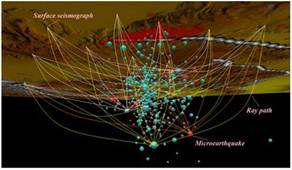
For example, lets suppose that we have installed a network of 50, 3-component seismographs all over the region of interest. In a tectonically active area we usually record more than 5-10 events per day average. If we record 5 events in 60% of the seismographs (that is we can recognize clearly seismic waves in 30 instruments) we get 5 events x 3 components x 30 seismographs= 450 seismic rays per day crossing our area. If we operate the network for 6 months we can end up with more than 80,000 seismic rays crossing our target.
9.
How do you manage so many waveforms?
LandTech’s software engineers have developed a great suit of algorithms to process the continuous seismological recordings, isolate microseismic events, determine the arrival times of the seismic phases and invert them for hypocentral determination and velocity models. A description of these software are described here: Click
10.
What about the case that the microearthquakes originate from a few single active faults?
In this case after a few months we move the seismographs in new positions in order to allow a complete ray coverage of the region of interest.
11.
Do all the microearthquakes have to originate only within the area of interest?
We usually put a small number of seismographs out of the area of interest in order to locate accurately the earthquakes occurring nearby some of which cross the target under various angles and can improve the resolution. Below is an example where most of the recorded seismicity is "out" of the region of interest (white rectangle). By installing a few stations around this region we were able to locate accurately the nearby events and use them for seismic tomography. In fact the most shallow events located away from the target area hit at low angle the investigation site and increase the resolution at the upper layers.
12.
How long can a seismograph be operated in regions with no electricity?
LandTech's LTSR-24 digitizer has been designed having the above question in mind. It is the lowest power consumption seismic recorder in the world since it writes directly from the A/D converter to the Flash card. It can operate with a single car battery for almost a month!. Furthermore , LandTech Engineers have used various ways of keeping their seismographs running even in very isolated regions. They use solar panels, Micro wind generators and recently the new technology of Hydrogen and Methanol cells.
13.
Can you apply this methodology in areas of very rough topography?
PST methodology is not affected by rough topography. Since we do not have to deploy many geophones or layout seismic lines and repeaters, and we do not have to use surface seismic sources it is extremely easy to operate in rough terrains. All we have to do is to install single stations at a spacing of about 5Km , use a GPS to measure accurately the coordinates and leave nature to provide the seismic sources! We have operated in thrust belts with topography ranging from a few m to a few Km above sea level.
If required we use helicopters to deliver recording equipment to remote sites to reduce layout and data retrieval time
14.
What about environmentally protected areas, swamps, tropical forests etc?
PST methodology is ideal for these cases. It is the only technique with no environmental impact. We have successfully installed passive networks in extremely environmentally sensitive regions such as in the Amazon and in National parks.
Click here for more details
At LandTech S.A., we care about the environment the land owners. We take extra precautions on our job sites to protect the environment.
15.
Can you operate offshore?
LandTech completed the design and tests of a unique Ocean Bottom Seismograph being able to operate up to depths of 10Km and synchronized via an atomic clock. This unit will be used by LandTech for offshore passive seismic tomography services.
16.
Can PST methodology be applied to regions where we already have conventional seismic (2D or 3D) data of bad quality in order to improve them?
Many of our clients have used PST results to increase the resolution of existing seismic sections. Click here
17.
Can we apply the PST methodology to areas with high noise (Industrial etc)?
Yes LandTech uses special installation procedures and noise filtering techniques to increase considerably the S/N ratio of the recorded data.
LandTech has developed advanced algorithms to reveal the P- and S- wave phases from very noisy data. Click here to read more about these procedures.
18.
Can you combine PST results with the results of Gravity and MT surveys?
LandTech was the first exploration company to apply joint inversion methodologies of Passive Seismic Tomography (PST), Gravity and MT data. This approach has significantly improved the resolution of the obtained geological models since PST, Gravity and MT data are dominated by different physical parameters (seismic velocity, density and resistivity). Various combinations of [PST,MT] ; [PST,Gravity] or [PST,MT,Gravity]data sets can be jointly inverted. Recently LandTech has developed a neural network joint inversion algorithm (GRAMAPAS)for the combined optimum inversion of PST, MT and Gravity measurements.
Below is an integrated representation of a characterization of an entire block using data from Passive Seismic Tomography, MT and Gravity
And below is the corresponding interpretation proposing new drilling sites as possible hydrocarbon targets
19.
Can PST methodology differentiate oil and gas reservoirs?
The Vp/Vs ratio is especially sensitive to the pore fluid found in sedimentary rocks. In particular, the Vp/Vs value is much lower (10-20%) for gas saturation than for liquid saturation.
In the figure bellow we depict 2 cross plot diagrams between [Vp/Vs],Vp and [Vp/Vs,Vs]for various depths. The values were obtained from a high resolution passive seismic tomography survey in a gas production field in Albania. For more details CLICK here to see a complete field case.
20.
Can the PST methodology be used for shale fracking and reservoir monitoring?
In contradiction of the existing today monitoring techniques, LandTech has developed special instrumentation and surface recording methodologies that no expensive boreholes and down hole instrumentation are needed. LandTech’s LT-FS surface sensitive seismometer (Click here to see specs) can record microseisms of negative magnitudes many Km down.
LT-FS ultra-sensitive surface sensor
LandTech has also developed a procedure which is based on the shear wave splitting phenomenon, to delineate fracture zone directions within the entire reservoir Click here to read more
LandTech uses specially designed surface seismic networks based on VHF or WiFly telemetry for real time reservoir monitoring, Click here to see more.
21.
Can we perform a passive seismic tomography survey over a very restricted area?
The minimum area that a PST survey can be performed depends on the background seismicity but in general it is not advisable to concentrate in a very restricted area because the number of microearthquakes recorded will not be adequate for the required seismic ray density. On the other hand the survey cost does not reduce in analogy with the survey area and it is better to install the network over a larger area.
22.
How easy is to interpret PST results?
The interpretation of PST results is very easy since we have 2 different kind of data e.g. Vp and Vp/Vs sections. Bellow we present some examples of interpreted sections superimposed on some geological structures.
Interpreted Vp section obtained by a PST survey
IInterpreted Vp/Vs section obtained by a PST survey
23.
How sure can LandTech be that the technology works?
LandTech has tested the technology on several different data sets from different basins in the world. The results have been verified with numerous wells and seismic data. The results have been accurate in all cases. We know it works!
24.
Is any relation between the so called Low Frequency Passive Seismic (LFP) method (or sometimes called Direct hydrocarbon indication) and LandTech’s Passive Seismic Tomography (PST) method?
Not at all!! Some companies state that a natural low frequency can be detected upon a reservoir. LandTech’s engineers and other researchers have thoroughly experimented on this methodology AND FOUND NO INDICATION of the existence of such a frequency, thus LandTech does not deliver this kind of services. LandTech’s PST method is based on the well-known in the seismology seismic tomography methodology and IT WORKS!
For farther proof’s that the Low Frequency Methodology is questionable the reader can download the following paper published in the Bulletin of the Seismological Science of America click here
25.
Can the Passive Seismic Tomography (PST) method be used for pinpointing hydrocarbon reservoir and drilling sites with reduced well risk?
Although a Passive Seismic Tomography (PST) survey provides mainly, structural and lithological information below the entire block of interest and cannot be considered as a direct hydrocarbon indicator in certain cases we can provide maps which depict sub regions within the investigated block possessing high probability for a successful well. This is due to the fact that one of the products of PST is and the Poisson's ratio which strongly depends on the fluid content within the pore space.
Furthermore, the mapping of the Q parameter all over an exploration block could reveal regions of high porosity, fracture zones and differentiate gas and oil in the pore space.
The decrease of Q (increase of attenuation) is obvious at the oil and gas depths
By combining the results of MT and Gravity surveys (if they exist) and imposing additional data limits corresponding to the hydrocarbon targets the probability to drill a producing well is farther increased, see FAQ 18.
26.
What are your guarantees.
Many companies have been satisfied about our services and we can provide numerous letters of recommendation upon your request click here
27.
How can you keep a seismological network consisting of many recording stations in 100% recording state?
LandTech, by designing and manufacturing its own seismic equipment has right in the place all the required replacement boards so any faulty stations can be immediately repaired.