PST Deliverables
Passive Seismic Tomography (PST) provides a detailed 3-D seismic Velocity (Vp,Vs) and Poisson’s ratio (ν) model of the upper few Km of the crust below the entire exploration block. Careful interpretation can transfer the 3D passive data model into a complete 3D subsurface structural and lithologic image.
The 3D model can be further used for:
- Definition of structural and lithologic features
- Locate possible hydrocarbon traps
- Better understanding of the geology in the area
- Use 3D Poisson’s PST data for direct reservoir indication
- Reprocess and improve existing 2D seismic using new velocity information
- Define upside potential
- Design a better seismic line distribution for any future conventional seismic

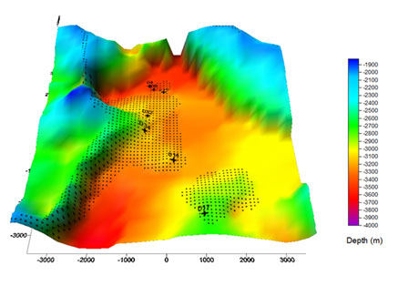
By imposing certain limits on the Vp and Poisson’s ratio values we can isolate of the entire exploration block regions possessing high potential for constructing a producing well. In the picture below proposed points for successful well, meeting selected criteria [4.5Km/s
Click here to see how you can locate a potential drilling site
LandTech’s PST service provides both P and S wave velocity data cubes using naturally occurring micro earthquakes as seismic sources (most of them occurring just below the study volume). Such tomographic imaging methods are particularly attractive since they provide not only structural but also lithologic (Vp/Vs) information that is difficult to obtain from conventional 2D and 3-D reflection surveys, and at a fraction of the cost of seismic reflection surveys.
The technique is particularly useful in complex geological and mountainous areas (thrust belts), regions encountering seismic penetration problems (sub basalt targets, heavily weathered top layers etc.). Since the seismic sources in PST surveys (microearthquakes) are within or below the target(s) of interest and we measure only the arrival times of P- and S-waves, the method does not suffer from seismic energy penetration problems, reverberations or complicated statics.
Furthermore, the assessment of the 3-D variations of Poisson’s ratio may indicate the presence of gas and fluids accumulations in sedimentary or fractured formations. In general a PST survey in tectonically active areas requires only a few months (6-8) of continuous recording of the seismic activity, which is comparable to the one required to complete a conventional 3D survey (particularly in regions characterized by difficult topographies, accessibility etc.). A full survey will require 6-8 months depending on the background seismicity of the area, but intermediate results can be obtained as early as 3 months after the start of acquisition.
In addition to the previous information we can farther analyze the recorded microearthquakes and calculate fault plane solutions and local tectonic stress distribution (stress tensor). These parameters are sometimes very critical in deciding the location of the planned wells and reduce the involved risk (drilling in a fault zone or in a region where the high compressional stress results in reducing the porosity or permeability of the geological formations).
Click here to see how to use PST results