Principles
Passive Seismic Tomography (PST) is a new revolutionary geophysical exploration technique utilizing the natural microseismicity, (microearthquakes with magnitudes of -1 up to 2.0 Richter) which occur almost everywhere, as seismic sources and a portable specially designed network of seismometers on the surface to record continuously for a period of a few months.
LandTech was the first company which introduced the method of high resolution passive seismic tomography for hydrocarbon exploration at a local scale, back in 1998. In addition to the specific hardware it has designed new inversion algorithms and neural network or fuzzy procedures for the reliable processing of the acquired passive data.
After determining the hypocenters of microearthquakes we use them as seismic sources embedded within or below the target of interest and perform 3D seismic tomographic inversion of the P- and S-wave travel times to the surface recorders.
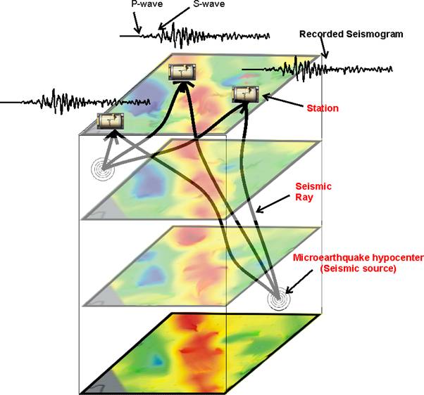
Since the seismic sources are below or within the target of interest we do not have a two wave travel of the seismic wave (in conventional seismic since the source is at the surface the seismic wave has to travel down and then up) but only one seismic ray path from the source to the surface, so this technique is specifically suited for regions of bad penetration problems (thrust belts, heavy weathered surface layers etc.).
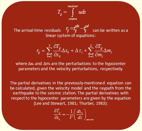
By modifying the 3D velocity model and the seismic ray paths and minimizing the difference between theoretical and measured travel times at the surface we end up with an accurate 3D velocity model.
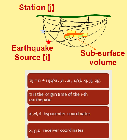
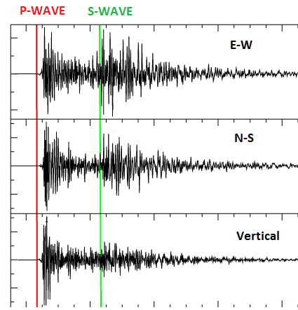
We can also measure the arrival times of S-waves, as well as other parameters too, that determine the attenuation of the medium (i.e. seismic amplitudes or first seismic pulse widths). LandTech has developed special algorithms to automatically detect the P- and S-wave arriving phases.
Thus Passive Seismic Tomography can give as a 3D image of P- waves, S-waves, Poisson's ratio and Quality factor (Q) or attenuation of the medium.Passive Seismic Tomography is the only technique which can provide 3D volumes of Poisson's ratio, a parameter which can indicate the presence of gas and fluids in a reservoir.
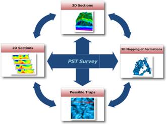
The basic steps of a high resolution passive seismic tomography survey are depicted in below
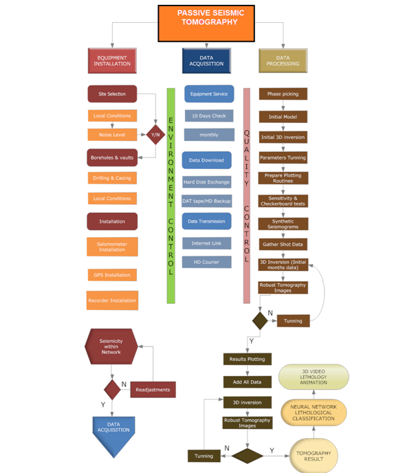

- The first step is data selection. It is important to use microearthquakes whose hypocenter locations are determined by the available data. This will not be a problem for a well designed seismic network.
- Determine the initial velocity model for the 3-D inversion. In order to construct the initial model, we will make use of all existing information. It will depend on the nature of the target area (i.e., the presence of strong lateral velocity discontinuities), whether to use a 1-D model or a two-sided model. In any event, the available geologic and seismotectonic maps, the seismic profiles (if available) and the initial 3-D models will lead us in this choice.
- Gather all data relative to the sources. That is separate the measured arrival times per earthquake and per station.
- Run the 3-D inversion on the initial data set and carry out the initial and first tuning of the parameters.
- Prepare all the plotting routines that will be needed in order to represent the resulting model adequately. (We generally use the public domain GMT package).
- Run the QC-sensitivity tests with synthetics. These include, for example, the checkerboard test.
- Run LandTech’s specially designed tomographic inversion algorithm with the final data set. This run, in reality, is an ensemble of runs in which the initial model can be changed from run to run and the data set can also be changed to verify the robustness of the tomographic images.
- Apply LandTech’s neural network based lithological assessment algorithm
- Plot the results: plan view maps at different depths, cross-sections, 3-D plots, plots of the residual times before and after the 3-D inversion. Plot the mean station residuals and their standard deviation.
- Perform the 3D animated video visualization analysis.
A detailed description of the theoretical basis of Passive Seismic Tomography is depicted in the scientific publications section Click Here
Click here... to see an example of a 3D Vp velocity structure below the whole of an exploration block obtained by LandTech’s PST method
Read More