Diving Wave Tomography
In addition to Wide Angle seismic surveys, LandTech’s special seismic services are designed to improve resolution and imaging in complex geological and topography settings (e.g. thrust belts), characterized by high velocity shallow layers, sharp lateral velocity variations, reverse velocity vertical gradients etc, where the quality of the seismic data is often poor or very poor, by applying innovative seismic data collection and processing techniques that will directly address the key issues which traditionally plague seismic data collected in these areas.
In this approach, the medium is typically parameterized as a number of cells. Turning rays are then traced through the model, and traveltime residuals are inverted for velocity perturbations in every cell crossed by rays. Since this method adds more degrees of freedom to the model, it generally fits the observed first-arrival moveouts better than headwave methods.
Diving wave tomography represents a robust method for evaluating 2D/3D velocities in very complex geological settings. With large offsets the diving rays reach the target’s depth and allow a more accurate reconstruction of the velocity field. LandTech uses a number of stand alone seismological stations spread all over the survey area to record deep penetrating diving waves and provides robust 3D velocity estimates which can be used as starting models for further more sophisticated steep-dip pre-stack depth migration in settings with little a priori subsurface information, passive tomography or reflection tomography processing.
Specifically, the model for diving waves includes vertical velocity gradients. This accounts for the nonlinear move out of first arrivals and allows for the solution to incorporate a wider offset range. However, the relationship between the model parameters and the traveltimes becomes nonlinear due to the significant sensitivity of turning-ray paths to the velocity model. The nonlinearity is usually handled by iterating the ray tracing and the model updating using a local linearization.
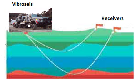
LandTech’s unique approach for this kind of surveys is to use instead of explosives a group of 2-5 synchronized powerful vibroseis to generate seismic waves which can be recorded up to many tenths of Km and cause no environmental problems.
By stacking many vib sweeps and special processing procedures LandTech can record signals up to tenths of Km and use them for 3D tomographic imaging.