Coal & Lignite Exploration
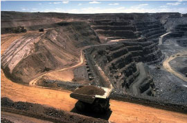 |
Drilling is the traditional and still the most common method used in coal exploration. Most coal companies rely heavily on borehole data to evaluate their mine properties. However for the Underground Coal Gasification (UCG) and Coal Bed Methane (CBM) it is necessary to map the subsurface coal and to detect other spatial properties of the coal seam with a high degree of accuracy. Here the geophysical technology plays a vital role. The following are some of the geotechnical methods employed in the international arena: |
- High-resolution surface seismic reflection and refraction
- Borehole geophysics: logging, VSP, & tomography
- Underground inseam seismic
- Borehole camera
- Ground probing radar
- Ground conductivity
- Electrical resistivity
Among the geophysical capabilities listed above, the surface seismic method is the most utilized because it is site specific and provides reconnaissance surveying capabilities to provide a lot of useful subsurface information, precise enough for mine planning and development. The surface seismic method had been successful in detecting geologic anomalies ahead of mining, such as faults, washouts and old (and flooded) mine workings.
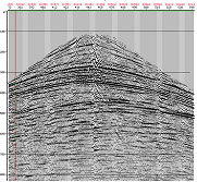
The resolution required for coal seam mapping is in the order of a few meters, both vertically and laterally. The field processing and interpretation procedures differ significantly from those in seismic exploration for oil and gas. Care must be taken in every aspect of the seismic program including survey design, data acquisition, processing, modelling and interpretation. The figure above depicts a typical high resolution seismic recording by LandTech’s geophysicists. A properly designed survey can result in significant improvements in safe and economic exploration and exploitation of lignite resources
LandTech provides advanced coal bed and coal bed methane exploration services using state of the art high resolution shallow seismic reflection methodologies. Below we present a 3D mapping of some lignite horizons from a coal survey in NW Greece.
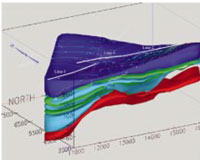
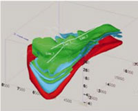
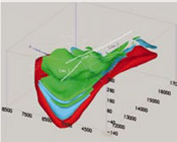
Blue, green, light blue and red correspond to overburden, lignite, sands&clays, and the conglomerate base respectively. The middle figure is after removing the overburden and the third figure is after removing the formations above the second lignite zone.
Click here to download details about this case history.