Magnetotelluric
 The realization that Magnetotellurics (MT) data can provide complementary information to that derived from seismic exploration. For example, the diffusive signal propagation used in MT can be an advantage in a region of intense fracturing. While seismic signals will be scattered, the MT signals diffuse and give a reliable estimate of bulk properties such as porosity. Just as in seismic exploration, electromagnetic geophysics can contribute to effective hydrocarbon exploration in two distinct ways.
At a basic level of interpretation, resistivity is correlated with different rock types. High-velocity layers are typically highly resistive, whereas sediments - porous and permeable - are typically much less resistive. While high-velocity layers are an acoustic barrier and make seismic ineffective, their electrical resistivity means the magnetic signal passes through almost unimpeded. This allows MT to see deep beneath these acoustic barrier layers, complimenting the seismic data and assisting interpretation.
(Phoenix 2004)
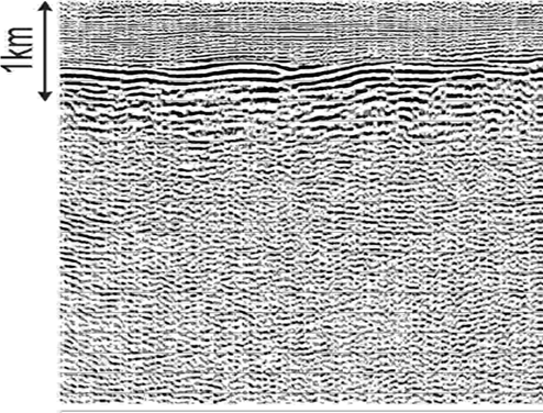
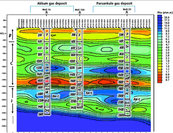
A highly reflective layer of dense Cenozoic rocks forms an acoustic barrier at a depth of about 1km. Seismic methods produce almost no information below this layer, as shown on the cross-section at left. MT exploration, however, clearlyshowed the presence of the oil-prospective layers in the Upper Paleozoic rocks.
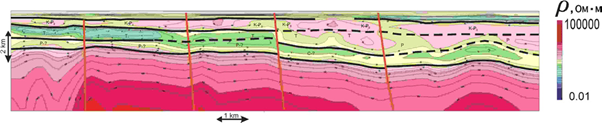
The presence of hydrocarbons in rocks is also associated with characteristic resistivity patterns revealed by MT - so-called "Direct Hydrocarbon Indicators"
LandTech has a permanent collaboration with Phoenix Geophysics a company which is a worldwide leader in MT equipment. In many cases Phoenix scientists in collaboration with LandTech’s Geophysicists work together on various MT projects.
LandTech’s MT survey teams use the following equipment manufactured by Phoenix:
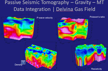
LandTech has developed GRAMAPAS® a joint Passive Seismic Data, MT and Bouguer gravity residuals joint interpretation algorithm. It consists of the reiteration of a set of n iterations of the seismological inversion, leading to a new velocity model and new event locations, followed by one inversion of the gravity & MT data and the computation of a new density contrast model.
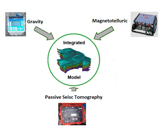
An example of a combination of PST, Gravity and MT data, obtained by LandTech in Albania, is presented below